Giza’s subsurface ‘Pyramid of Records’ revealed in documents from the Cayce Archives
May 31, 2026, By Trevor Grassi
Edgar Cayce, the Sleeping Prophet, in many of his psychic readings spoke of records that were stored underground at the Giza Plateau, and specifically, near the Great Sphinx. He indicated that the records had been carried there from Atlantis, in the final years before the last cataclysms sank the land, around 10,500 BC. Today, we are publishing images from the Cayce archives that have never been public before, and which provide more information about the location of these records and how to access them. Below is a full written report with high resolution images, and we have also presented a video here:
Cayce’s references
Cayce was not the first to suggest a subterranean pyramid. There was at least a visual reference to one in the 1913 image published by The Sphere, supposedly based on the excavations of George Reisner.
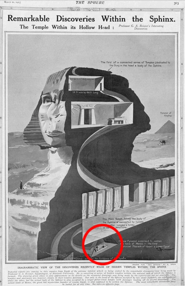
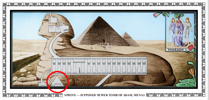
The following year, the image was basically copied and drawn from a different perspective for Charles Taze Russell’s Photodrama of Creation.
Still, neither illustration came with any substantial explanation of the pyramid structure, so it was Cayce who first elaborated on it. While he most often referred to a ‘Hall of Records’, he also mentioned a ‘Tomb of Records’ and ‘Pyramid of Records’.
36. (Q) Where are those records or tablets made of that Egyptian experience, which I might study? (A) In the Tomb of Records, as indicated. For the entity’s tomb then was a part of the Hall of Records, which has not yet been uncovered. It lies between – or along that entrance from the Sphinx to the temple – or the pyramid; in a pyramid, of course, of its own.
37. (Q) Through what channels of the Association for Research & Enlightenment may the entity gain the most? (A) As it begins it s further preparation and activity, seek through those channels for guidance – as it is felt that it is needed; or begin with the interpreting of the tablets. For, remember there are thirty-two of these plates!
Edgar Cayce Reading 2329-3
It would seem rather likely, given the evidence presented in this article, that we may well have located both the tomb and the pyramid already! At least, we have significantly reduced the search to a radius of roughly 50 meters.
In The Secret Underworld of Giza documentary series (Part Two: The Tomb of Records), William Brown told the story of a tomb that was discovered in 2010, during an illegal excavation in the village of Nazlet El Samman, just outside the enclosure wall of the Giza Plateau. The location was no more than 150 meters northeast of the Sphinx, in what we described as the most likely location for the records to be found, based on the clues given by Cayce. A few relevant readings are included here:
When there was the entrance of Arart and Araaraart, they begin to build upon those mounds which were discovered through research. With the storehouse, or record house (where the records are still to be uncovered), there is a chamber or passage from the right forepaw to this entrance of the record chamber, or record tomb. This may not be entered without an understanding, for those that were left as guards may NOT be passed until after a period of their regeneration in the Mount, or the fifth root race begins.
Edgar Cayce Reading 5748-6
…
(Q) Did I have any constructive part in either the building of the Great Pyramid or the records therein?
(A) They are in the records of the pyramid of records, not the Great Pyramid. The Great Pyramid was the initiating building. The records are in the Temple, or pyramids of records of the entity. To be sure, these will be a part of the experience some time when these are unfolded.
Edgar Cayce Reading 2390-7
…
Hence we find the entity then, Ax-Ten-tna, as would be said in the present, was the first to set the records that are yet to be discovered, or yet to be had of those activities in the Atlantean land, and for the preservation of the data, that as yet to be found from the chambers of the way between the sphinx and the pyramid of records.
Edgar Cayce Reading 1486-1
The ‘Tomb of Records’
The story of this tomb ended in a terrible tragedy, as at least six men were buried alive by a collapsed shaft. Worse still, the evidence demonstrates that it was not an accident, but intentional, and clearly done with the motive of silencing all those who saw the tomb, and recovering the sarcophagus from within it. It was hauled away swiftly, but some local witnesses believed it was the mummy of an extraterrestrial. Everyone who came into a close proximity of the sarcophagus felt a surge overwhelming emotion, including the chief of police, who broke into tears after seeing its face.
Cayce’s readings referencing a tomb of records may be interpreted to mean that the DNA of specific mummy, could itself be considered a record. He never mentioned the form that the records took exactly, though at one time he described 32 stone tablets (cited above), but this was clearly only one part, and the whole of it. It is far more likely that the records take many different enduring forms, and are stored throughout many different chambers or areas. This could include inscriptions directly into stone walls or bedrock chambers, stone tablets, mummified DNA, architectural codes hidden in plain sight, and it could even be stored as ‘pure information’, much like the files we store on modern hard drives. Quartz crystal or structured water, for example, can both store energy or information in a similar way, and there is sufficient evidence to prove that the Egyptians were aware of this. (See The Prosperity Machine)
We may never know if the tomb that was found was the very same tomb of records Cayce mentioned, or if it was one of many, but it is definitely a very strong candidate, and it is certainly an immense loss for humanity that such an important discovery was sabotaged and violently covered up. We can only hope that the same fate will not come to the Pyramid of Records.
The Pyramid of Records
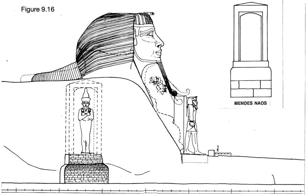
To that end, we are releasing documents today that come from the Cayce Foundation’s own archives (also known as the ARE; Association for Research and Enlightenment), placed there in the late 1970s, which demonstrate in clear illustrations, exactly where they believed the pyramid could be and how it might be connected to the Sphinx.
These illustrations were first revealed in presentations at the ARE’s annual Ancient Mysteries Conference, given in both 2024 and 2025 by Laura Hoff. Laura works in the library and archives at the ARE headquarters in Virginia Beach, and she is also an independent researcher passionately driven to the search for the lost records Cayce described. After seeing her presentation in 2024, I asked her more about these images and she helped to arrange our permission to release them publicly, so we owe sincere thanks to her, for making these documents known.
In the 1970s, Hugh Lynn Cayce (Edgar’s son) was working directly with Dr. Zahi Hawass and SRI (Stanford Research Institute) at the Sphinx, in an effort to follow up on clues left behind in the readings with modern methods like seismic surveys of the underground. There are a few public reports on this work, including one from Lambert Dolphin, who directed the mission for SRI, called Geophysical Studies around the Sphinx (1978).
Mark Lehner was also involved in the excavations and wrote a 500+ page thesis called Archaeology of an Image, found here with separate documents linked below it containing the figures and plates.
The ARCE (American Research Center of Egypt) also provides some additional information here.
Yet in all these reports, they never truly let on to what they were looking for exactly. The images we share today can answer that question. They were searching for the Pyramid of Records. In the wake of remote viewings by Ingo Swann, and with all the clues Cayce provided, even the CIA were highly interested in locating the records, and this may even have been what prompted the SRI investigations.
The document left in the Cayce archive has little context. No author’s name is cited but a few paragraphs of explanation were included with the images. The year 1979 is the only one that appears, and it is assumed that this was the year the document was made and stored in the archives, though this is not entirely clear, and the project at the Sphinx had begun several years before. The related text (copied in transcript below) clearly states that the diagrams are purely hypothetical, to illustrate the potential layout, though further analysis of the situation provides a better idea of the allowable percentage of error, and drastically reduces the search area to a concentrated zone.
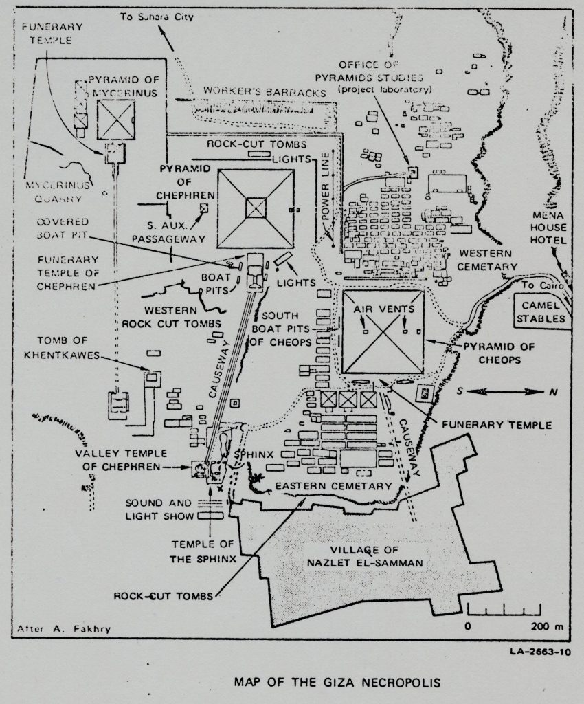
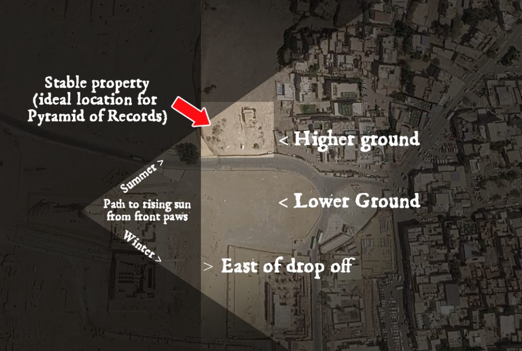
The first image was presented by Laura in 2024, and those that followed, in 2025. The first shows an aerial view map that indicates a tunnel originating at the Sphinx’s right shoulder and bearing northeast to the pyramid of records under the village area. It is labeled as a subsurface pyramid, notably, in the very location that we had highlighted only a year earlier in our film referenced above (Secret Underworld: Part 2) – very close to the supposed Tomb of Records, but exactly below the horse stable that Bill Brown had purchased in 2010.
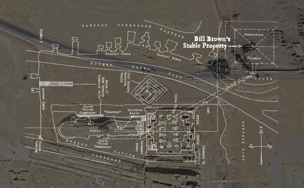
Knowing that SRI was carrying out extensive analysis on the whole area, we can understand that this map is, at least, a highly educated guess. It is backed as well, by all the most extensive research from the staff of the ARE, including Cayce’s own son. It is an unprecedented confirmation of Bill’s previous claims about the location.
In reading 378-16, Cayce indicates the actual direction of the tunnel from the Sphinx to the Pyramid. The location Bill and the ARE both independently identified as the ‘record hall area’, is confirmed by my photo of Bill’s Stable directly under the sunrise, from the Sphinx’s front paws. Though in the winter the rising point drifts south, it nevertheless proves that it is within the range Cayce’s description.
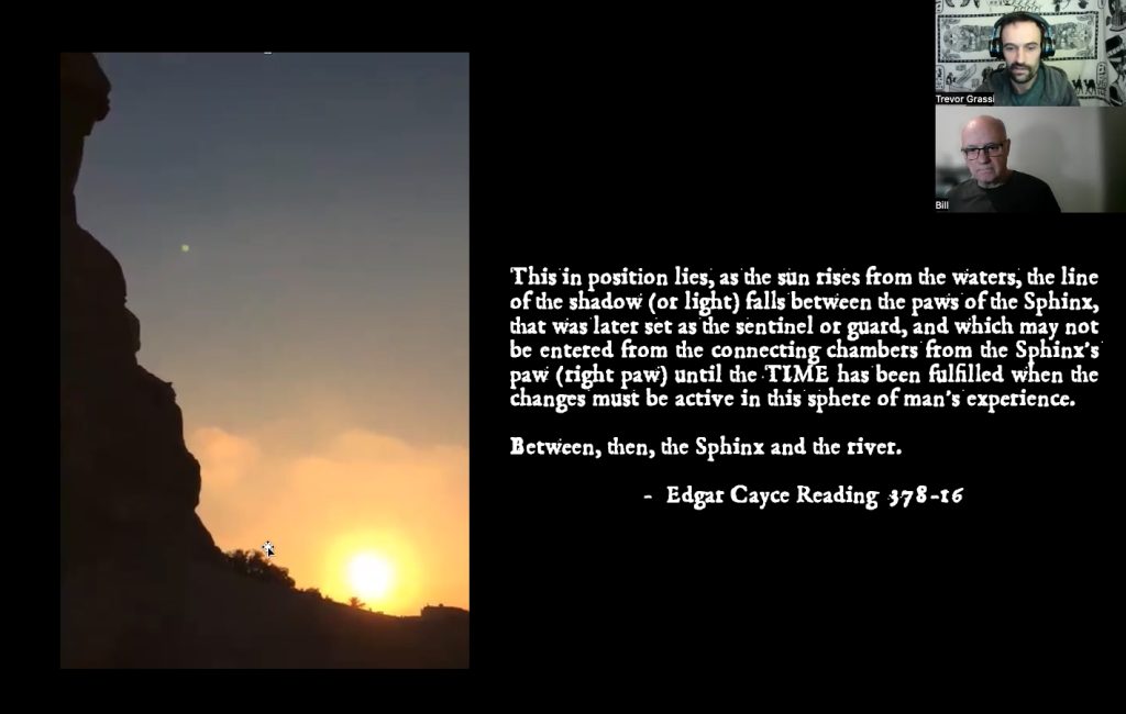
The line of shadow of the Pyramid in that location, could be cast by the rising sun on the paws of the Sphinx. It seems implied that Cayce is saying this hypothetically, as if the pyramid was built tall enough to cast such a shadow, though his various references imply that the Pyramid of Records is completely subterranean, and intentionally hidden.
Below is a full transcript of all the text we were given and a total of nine additional images, including three vertical cross section diagrams, another aerial map, and five photographs.
Transcription
Transcribed directly from associating archival document for Ancient Mysteries Conference 2024.
(Document undated)
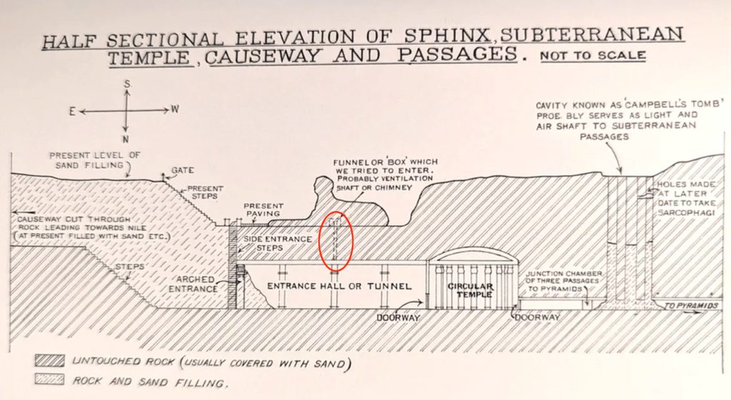
The elements shown in the following diagrams of the Sphinx area are not necessarily to scale. These diagrams showing underground monuments and passages are only conjecture as far as these features are concerned and are given to aid in conceptualizing possibilities as to how such passages and monuments might exist within present topography and bedrock. Scale diagrams would more fully aid in determining what is feasible. Since the Cayce readings frequently refer to the records as being in a buried pyramid, the main attempt has been to conceptualize this feature with a passage connecting to the Sphinx. The interior chambers of the conjectured pyramid are especially not to scale. The problem of the water table has been ignored in these diagrams. The line of cross-section does not necessarily correspond with the line of passages shown.
Fig 2: Cross-section of the Sphinx area and conjectured passage system connecting with a pyramid built against a subsurface ledge cut into the bedrock. Other possible elements are added. The Cayce readings indicate, in at least one instance, that there could be burials within subsidiary pyramids along the way from the Sphinx to the pyramid of records (2329-3, A.7). The “NW Corner Chamber” is conceptualized after reading 195-14 which states that data concerning the building of the Sphinx “may be found in the vaults in the base of the Sphinx,” and “in the corner facing Gizeh (Pyramid? Hence NW corner?) may be found wording of how this was formed…” The “Storage Chamber” is after reading 1925-1 indicating great storehouses “in those pyramids or mounds not yet uncovered.”
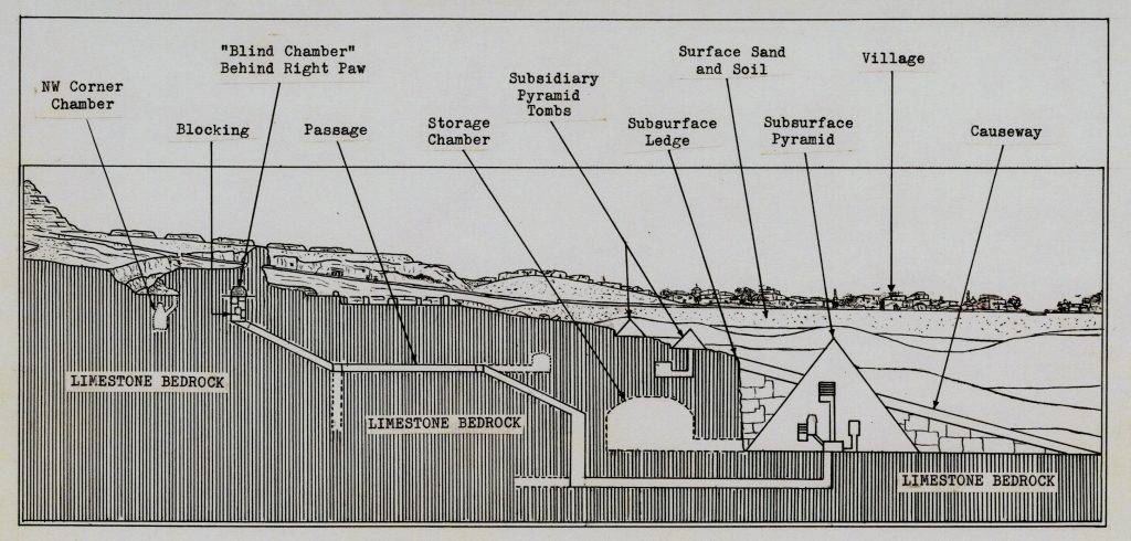
Fig 3: Cross-section showing possibility of a pyramid built into a pit out into bedrock off to the front of the Sphinx area. To be concealed, the pit, in this case, would have to have been filled in, perhaps with blocks covering the fill. Roofing over an unfilled pit of this size would have been difficulty and demanded the use of pillars or extremely large blocks (if this diagram were to scale, the blocks would have to have been as long as the Sphinx).
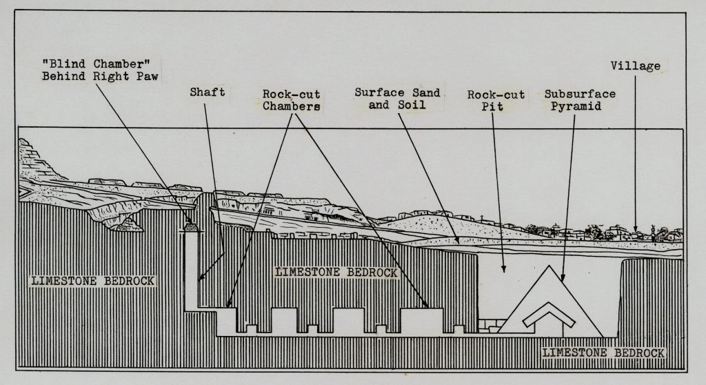
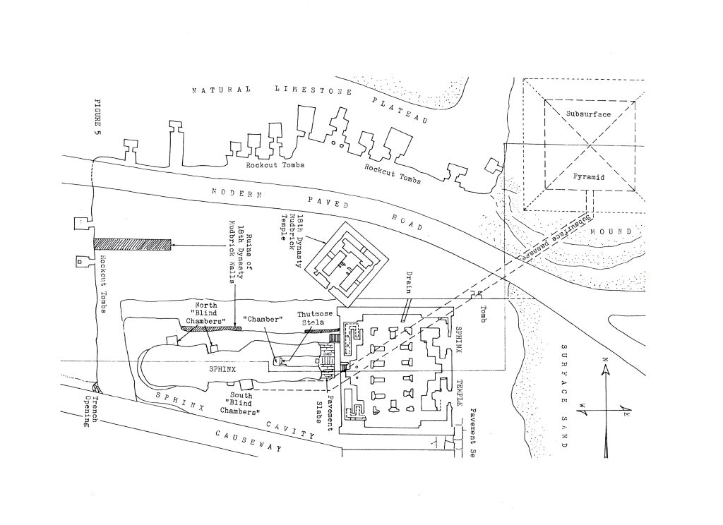
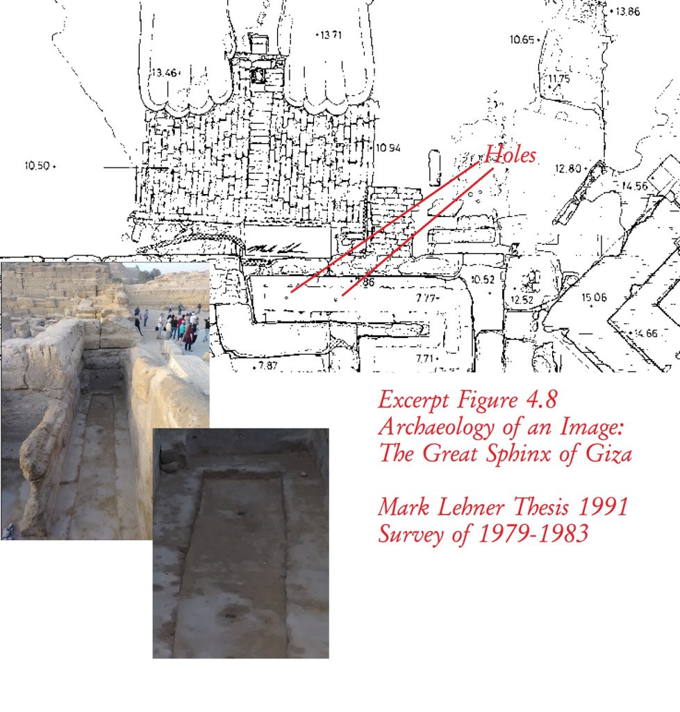
Fig 4: Cross-section showing the buried pyramid incorporated with the extant mound NE of the Sphinx. The line of cross-section does not correspond with the line of the underground passage (see Fig. 5).
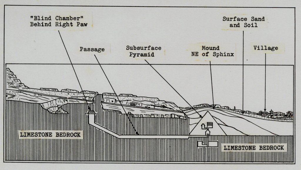
Fig 5: Plan of Sphinx area modified from that of Salim Hassan (Excavations, VIII, P1. XVI). Red line indicates line of cross-section in Fig. 4. Subsurface passage and pyramid correspond to that in Fig. 4. In Ricke’s more carefully surveyed diagrams (Beit. zur. agyp. Bauf. Und Alter. Heft 10, 1970) the E*W axis of the Sphinx Temple, through the eastern and western wall recesses, passes more to the south along the side of the right paw to the position of the “blind chamber” behind the paw.
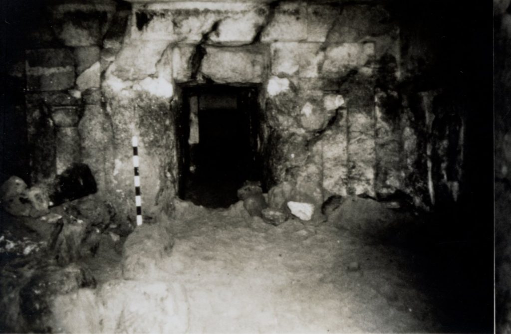
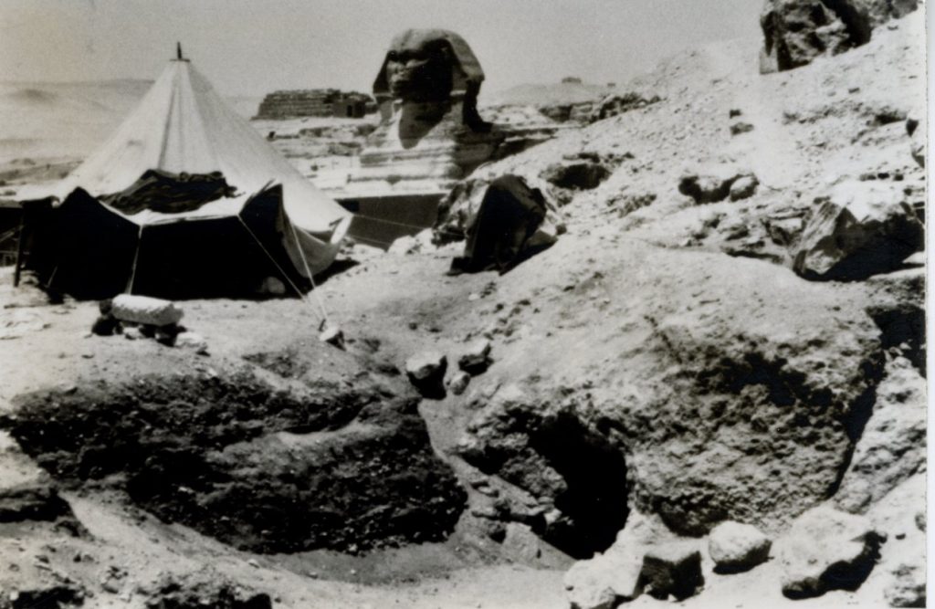
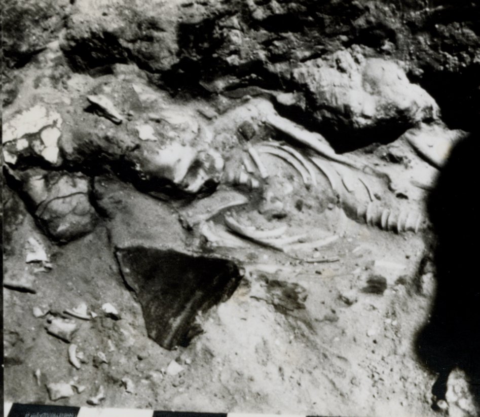
Context of Photographs:
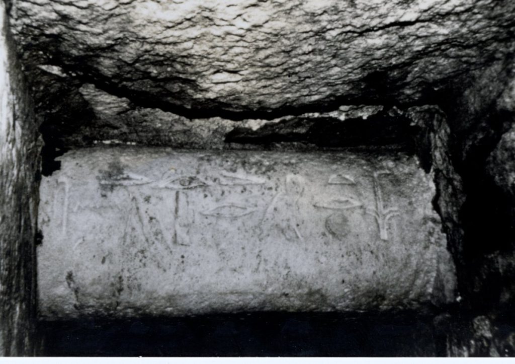
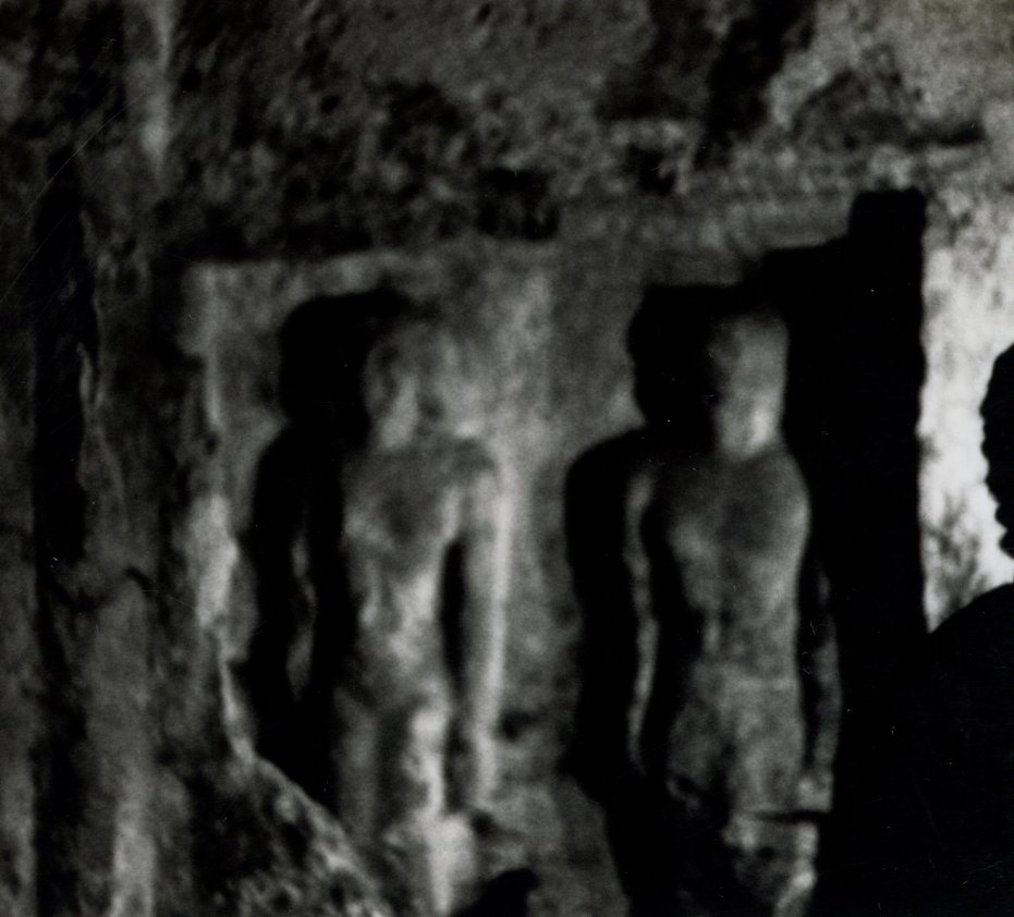
(1979) Large mound directly across the road and northeast of the Sphinx was dug. There a tomb, dating back to the time of Khufu, was discovered. Both the hieroglyphs and the carvings indicated the burial of one of the men responsible for workmen on the Great Pyramid. This tomb has been robbed and used again during Roman times.
[End of Transcript]
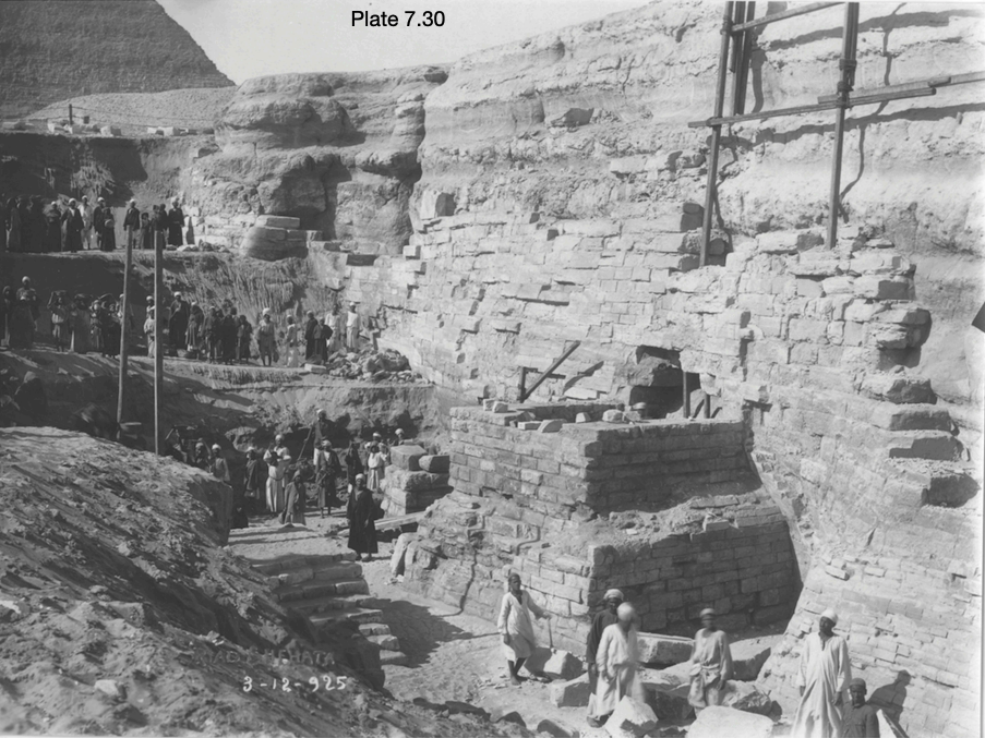
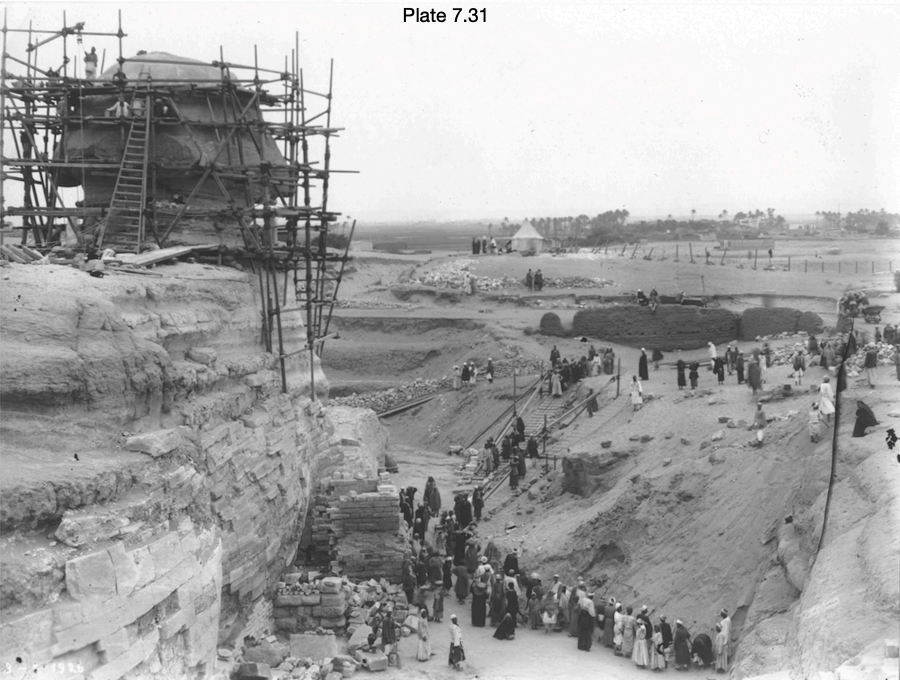
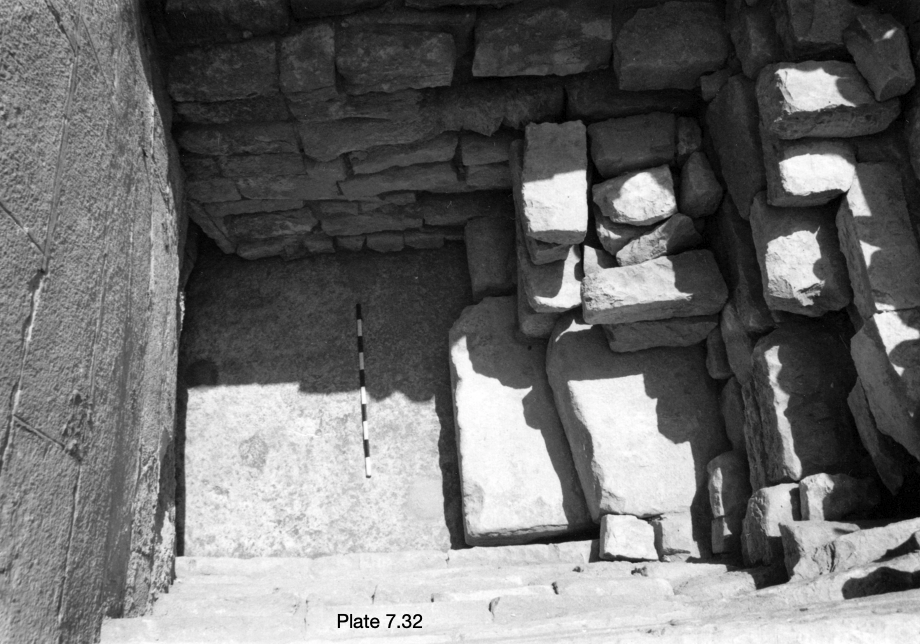
The five photographs show the interior an underground tomb suggested to be from Khufu’s time (Fourth Dynasty) at least, but robbed and reused in Roman Times. The dating is likely based on the hieroglyphs seen on the door lintel. At some point after these photos were taken, the entire area became full of sand and waste material, until 2010 when Bill Brown organized the ‘Cave Cleanup Project’ (also described in Secret Underworld, Part two: The Tomb of Records), uncovering at least five of the buried entrances. Three of these were soon cemented shut and masked into the bedrock and two others were sealed with locked metal doors. The tomb shown here in the 1970s, is likely behind one of those five entrances, none of which we can examine today.
Supporting Evidence
The vertical entrance shaft
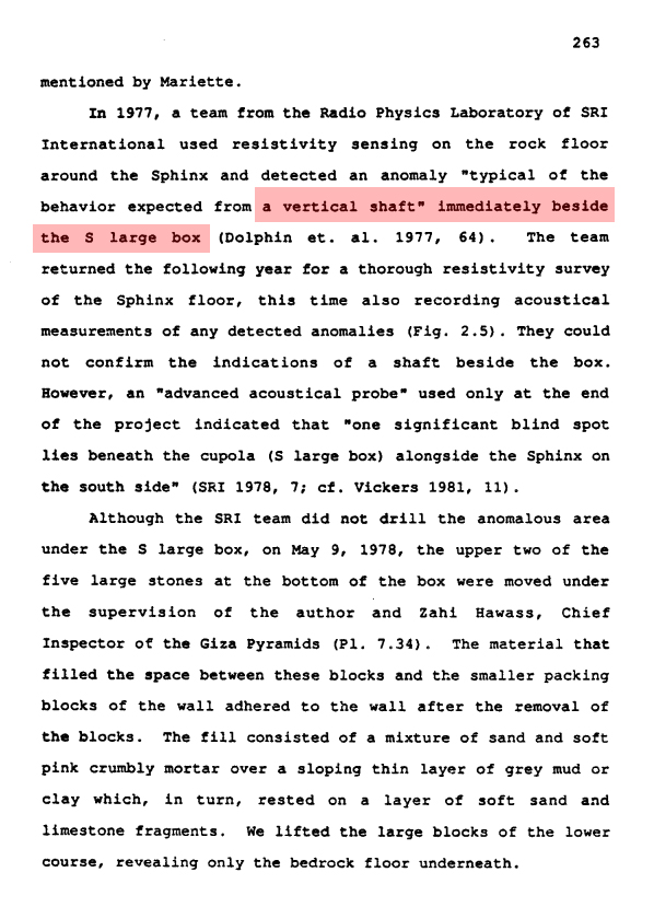
Even as a hypothetical layout, these diagrams give us a wealth of information, especially considering evidence of many of the features illustrated such as the drop off underground or the entrance shaft to the tunnel. Dr. Mark Lehner was working closely with the team of Hawass, Hugh Lynn Cayce and SRI. In Archaeology of an Image, there is a confirmation that a vertical shaft does exist, essentially at the exact location the ARE document illustrates. On page 263, he writes:
“In 1977, a team from the Radio Physics Laboratory of SRI International used resistivity sensing on the rock floor around the Sphinx and detected an anomaly “typical of the behavior expected from a vertical shaft” Immediately beside the S large box (Dolphin et. al. 1977, 64).
The team returned the following year for a thorough resistivity survey of the Sphinx floor, this time also recording acoustical measurement of any detected anomalies (Fig. 2.5). They could not confirm the indications of a shaft beside the box.
However, an “advanced acoustical probe” used only at the end of the project indicated that “one significant blind spot lies beneath the cupola (S large box) alongside the Sphinx on the south side” (SRI 1978, 7; ct. Vickers 1981, 11).”
Reference document: Archaeology of an image, Mark Lehner
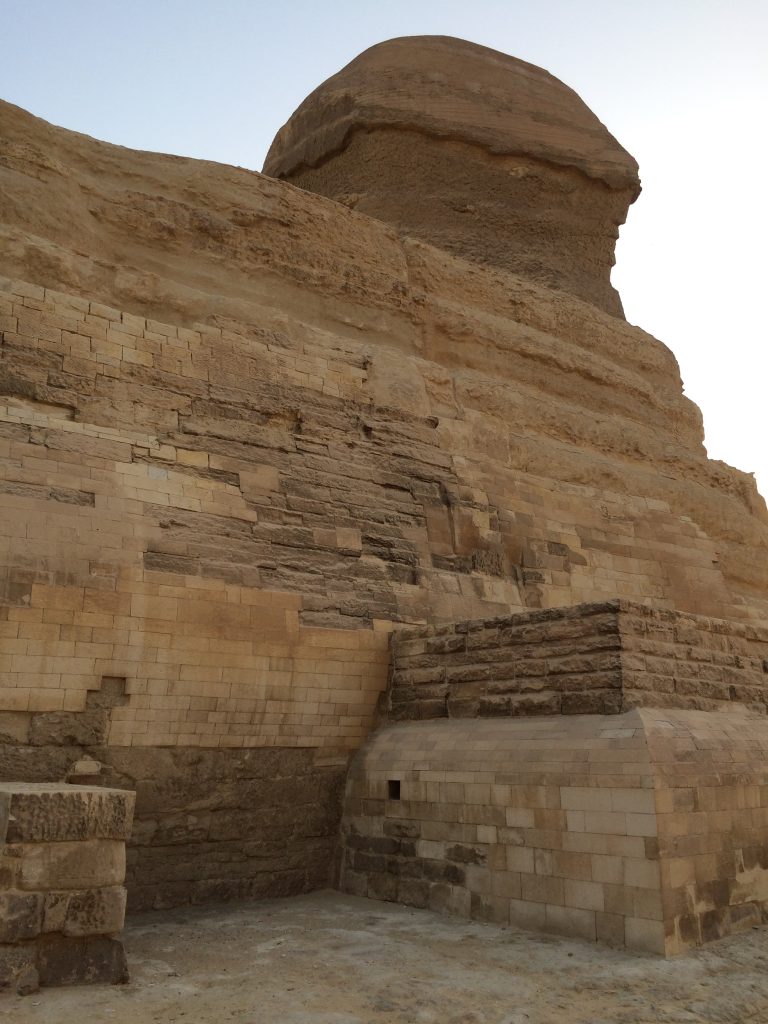
So SRI did detect a vertical shaft descending from what they call the ‘South Large Box’ at the Sphinx’s right shoulder!
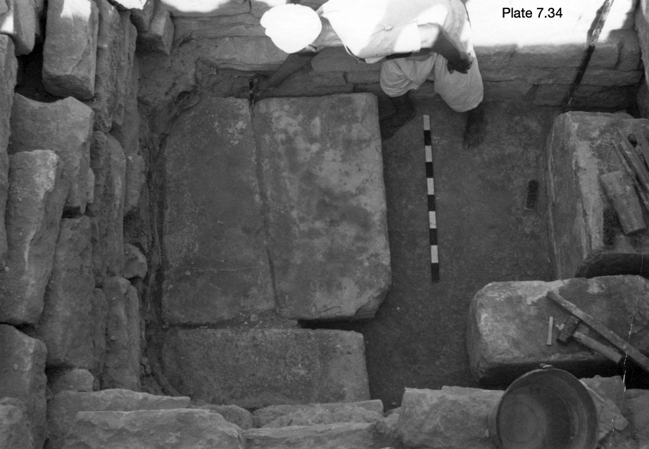
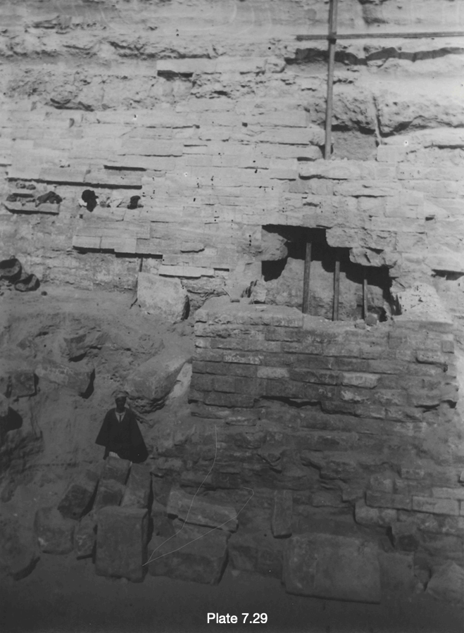
Lehner also provides some photographs from the excavations of the South Large Box by Emile Baraize in the 1920s. He found, carved into the Sphinx’s body within it, what appears to be evidence of past attempts to access this vertical shaft, if not the actual entrance to it. On Page 260 he wrote:
“When Baraize first cleared the S large box in 1925, it was mostly intact, although a big hole had been forced through the Phase I masonry against the part of the body enclosed by the box. Inside this hole, two large pieces of shaped limestone, as indicated in Arch. Lacau photo CI 63 (Pl. 7.28), may be parts of the Osiris statue. The piece with one rounded side could be part of a torso. The photographs show what appears to be the bedrock of the core body behind these limestone pieces (P1. 7.29).”
-Mark Lehner, Archaeology of an Image
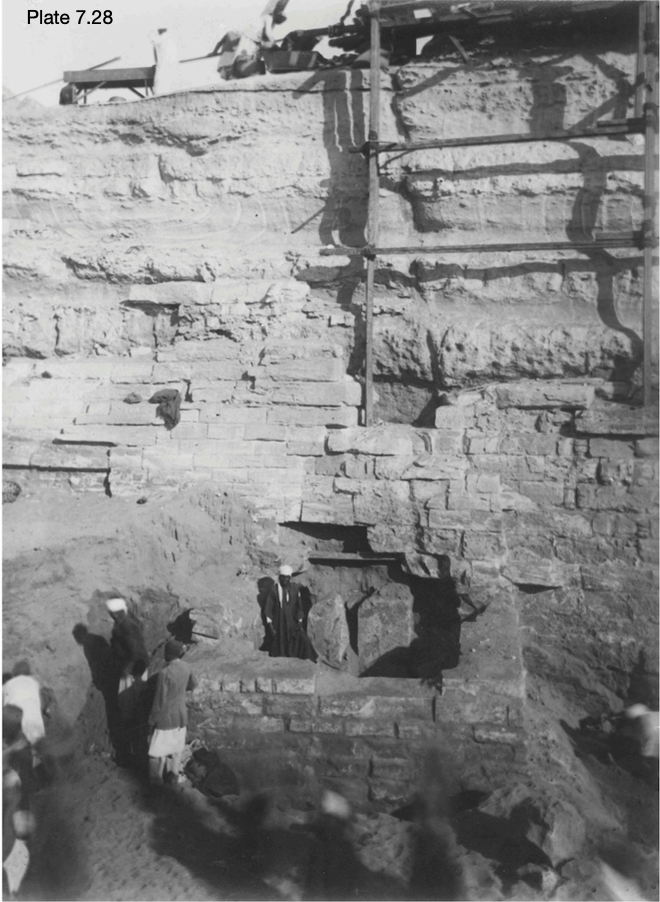
Pieces of a colossal statue of Osiris were found by the Baraize excavation inside this box, leading him to the conclusion that it was once a platform with the statue on top. This could potentially hint that the shaft also connects to the Osiris Shaft directly to the west. We have provided a large body of evidence for the main tunnel between the Sphinx, the Osiris Shaft and G2 (Khafre Pyramid), roughly following beneath the Sphinx Causeway, especially in Parts 5 and 6 of the Secret Underworld of Giza.
This tunnel connects to a central hall beneath the body of the Sphinx, and this main hall can very likely be accessed by way of the Large South Box shaft. From there, tunnel connections may be found to both Anomaly A, beneath the left paw (the chamber discovered by John Anthony West, Dr. Robert Schoch and Dr. Thomas Dobecki, 1992) and also, the Pyramid of Records further east. Anomaly A, in fact, may be one of the chambers that Cayce described as being ‘along the way’ between the Sphinx and Pyramid of Records.
Baraize resealed the hole that was forced into the body and his repair stones stones can be seen inside the box today. Sadly, Lehner refers to the statue as ‘missing’ today. Still, the forced entry that Baraize found evidence of is reason to believe that a shaft beneath the box was known to someone in the past, and there was an attempt to access it.
We should also note that the shaft was shown in the diagrams published published by H.C. Randall Stevens in A Voice out of Egypt (1935) and Harvey Spencer Lewis’ The Symbolic Prophecy of the Great Pyramid (1936).
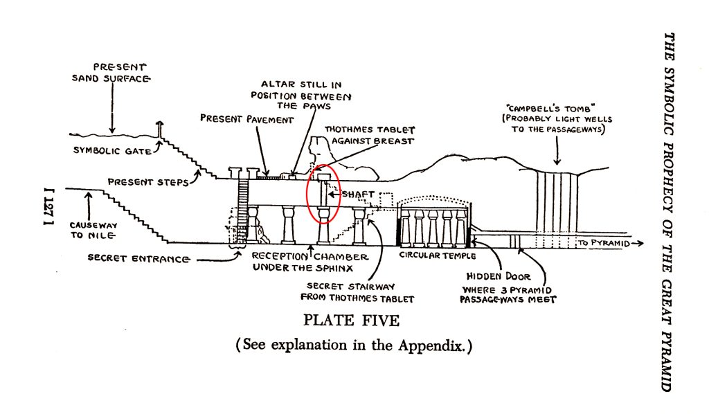
Though these images have been disputed for over ninety years, I recently revealed the original source map that was used for both, and was drawn as early as 1932 by Emile Dantine, who was on the ground at Giza while professor Selim Hassan was excavating what the press called a ‘secret city’ under the pyramids. It is likely that Dantine was in some of the tunnels himself with Hassan, which brings validation to the illustrations. This was explained in The Secret Underworld of Giza Part 6: Lost Map of the Rosicrucians.
Not only is the shoulder shaft present in the diagrams, but it is also shown to connect to the large hall under the body. The large hall may not be drawn to scale, but it is described as connected by tunnels to all three pyramids. On course to the Khafre Pyramid, the tunnel also connects to the Osiris Shaft just beneath the 3rd (deepest known) level. This was confirmed by additional evidence I revealed from seismologist, Dr. Thomas Dobecki in The Secret Underworld of Giza Part 5: Sphinx Tunnels Confirmed.
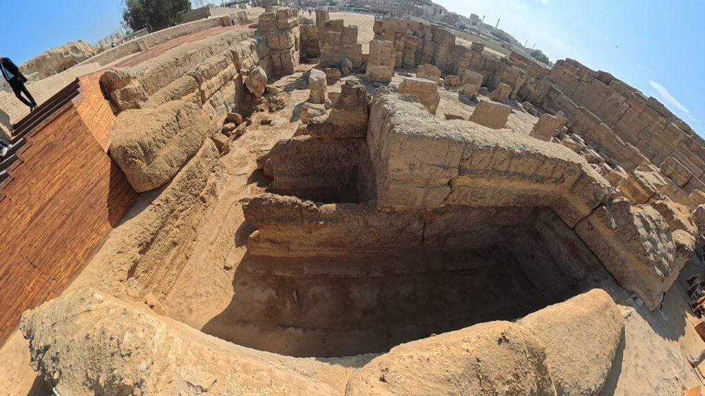
Boreholes in the Sphinx Temple
Mysterious boreholes drilled into the floor of the Sphinx temple provide additional evidence that there have been searches for the tunnel proposed in the ARE document.
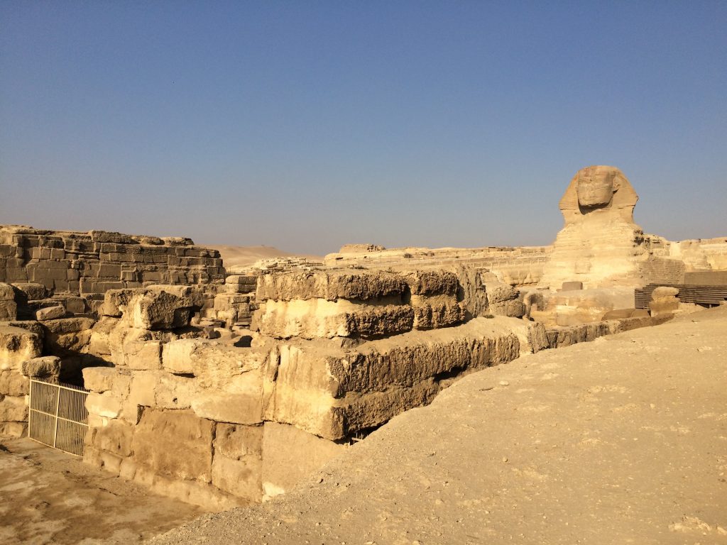
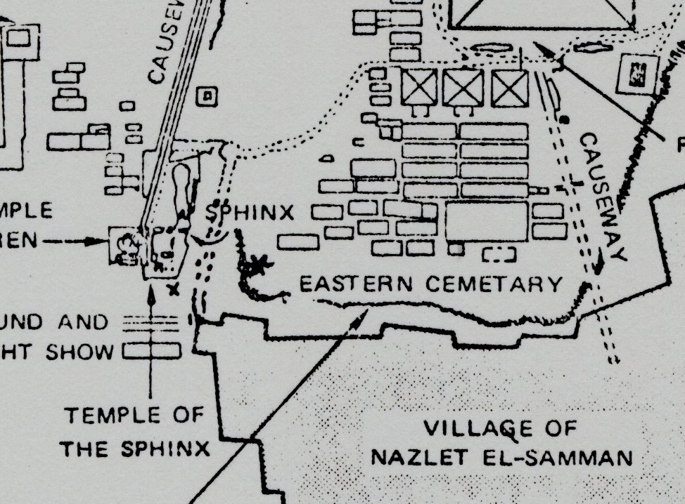
Looking southwest over the Sphinx Temple, we see the area above the tunnel. On the West end of the Sphinx Temple, there are a number of boreholes drilled into the ground, very close to Anomaly A, as well as to the illustrated tunnel to the pyramid of records.
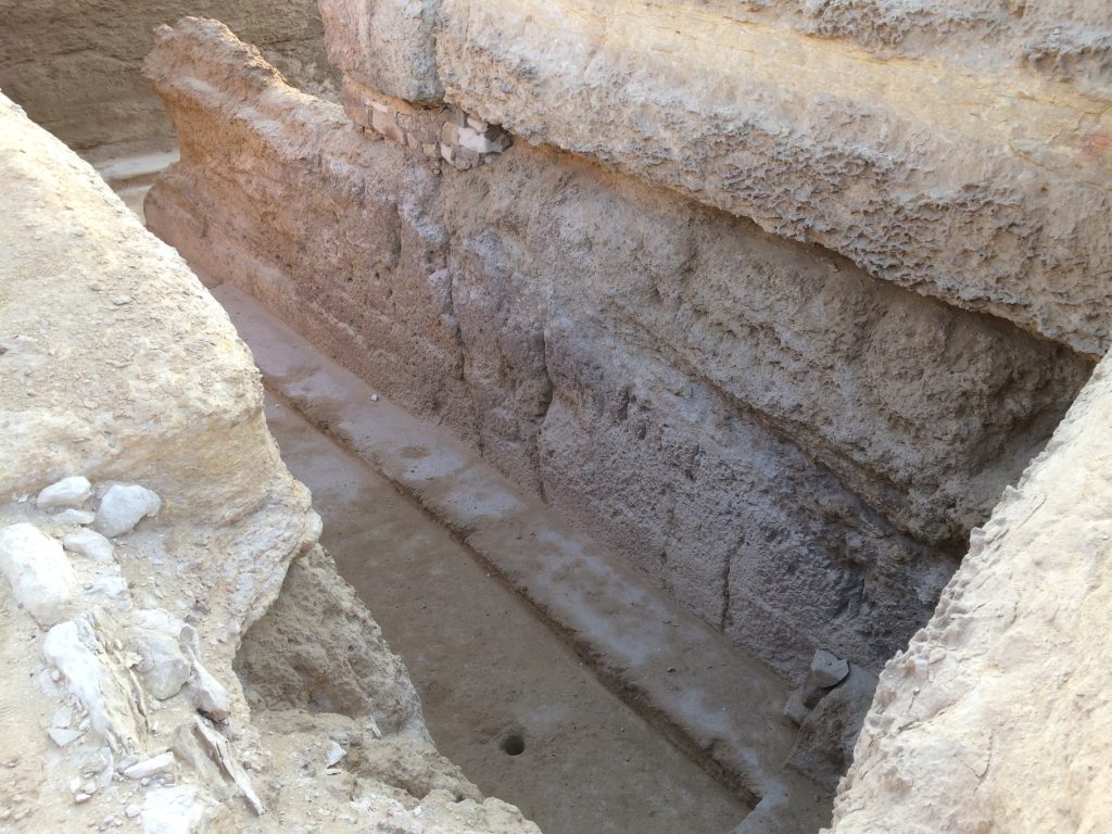
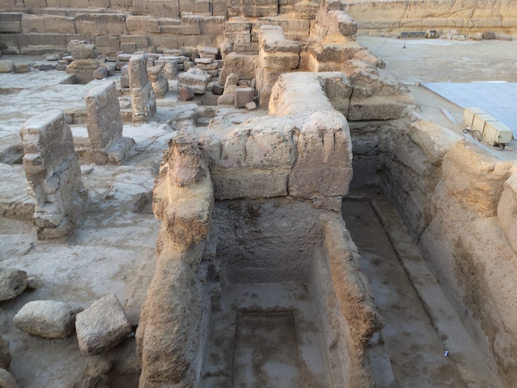
I took the photos above in 2019, while visiting the Sphinx Temple with Dr. Robert Schoch and the Organization for the Research of Ancient Cultures. Earlier this year I took another, finding that the holes were filled in and no longer visible. They have never been mentioned in any reports I am aware of, but four of them can be seen on the ARE map.
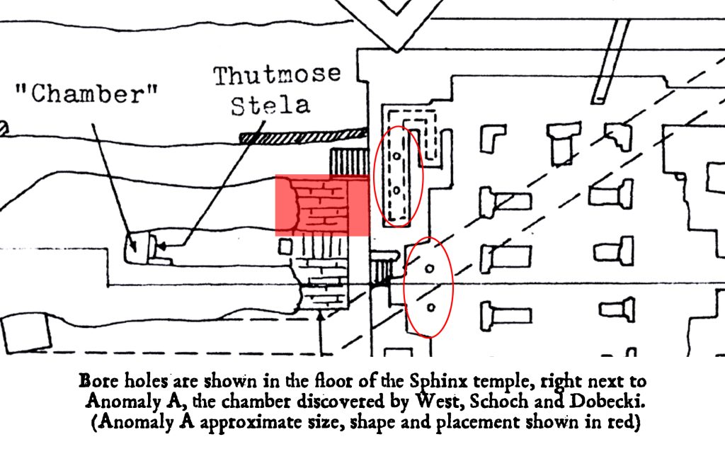
Dr. Manu Seyfzadeh, author of Under the Sphinx, is the only person I have ever seen reference the holes at all. He observed that they may have been drilled by Marjorie Hansen and her mysterious unnamed friend.
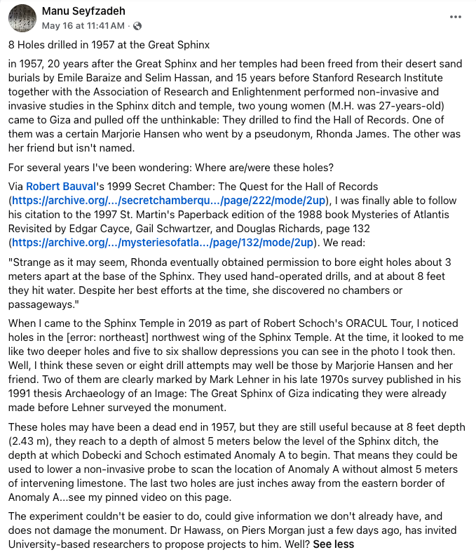
Marjorie was the first person to conduct on-site research at the Sphinx that was based directly on Cayce’s readings, so if the holes were drilled by her, it was indeed motivated by a search for the very same tunnel that would lead to the Pyramid of Records. She was an inspiring pioneer in this search, though little is known of her life and few have heard of her. Even the name Marjorie Hansen (sometimes spelled Marjorey) appears to have been a pseudonym.
Laura Hoff had mentioned her to me in the past, while sharing additional research of her own into the Hall of Records. I came to share Laura’s great respect for Marjorey, though I also know that she was able find very limited information about her life, even after searching through the ARE archives.
Manu makes another important point in his post; that if the holes exist, we might as well drop compact sensing equipment down into them in order to scan Anomaly A from the side, as it may be only inches to the west of the holes. Sadly, this may not be possible anymore, as the fill was likely cement.
The subterranean cliff and red granite
In Lehner’s thesis, he also explains the core drilling conducted in 1980, that resulted in the discovery of Red Granite at the base of a cliff or drop off entirely buried by sand.
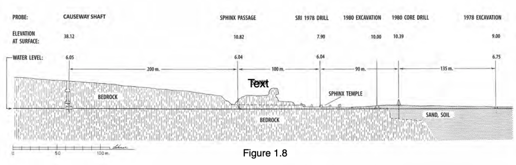
Hawass and Lehner believe it was a harbor in the Fourth Dynasty, and the steep drop off of the cliff allowed Nile boats to dock just in front of the Sphinx Temple. It has been suggested that the red granite stone found in the core sample may have been a block that had fallen off a boat and nothing more. Alternatively, it may be a constructed temple, or part of the buried pyramid.
In the Ancient Egypt Research Associates AERAGram, Volume 15 Number 1 (2014) Lehner illustrates their proposed model of the Fourth Dynasty harbor, showing the drop off as the water’s edge.
While the current water table makes it difficult to excavate to the base of the drop off, an attempt was made in 2010, though not transparently. Water pumps, a drilling rig and sandbags could be seen around a dig site very close to the red granite discovery, yet no official report was ever released about the work, and it was largely overshadowed at the time by major constructions all around it for a Red Bull sports event held in front of the Sphinx.
We still don’t know what is at the bottom of the cliff, but we know the drop off is there and that the red granite came from Aswan 100’s of kilometers to the south. There is no natural granite in the Giza’s limestone bedrock.
The water table
While the water table complicates the possibility of a buried pyramid of records, it does not make it impossible. It does, however, give us more reason to push the location further north, rather than due east of the Sphinx, as the Stable Area is on slightly higher ground, allowing more space between current ground level and the water table. This is in addition to the statement about the rising sun’s shadow, which also directs us to look slightly north of east from the right paw, and assuming that the pyramid is in front of (or east of) the drop off, our search area is considerably narrowed.
Glen Dash Survey
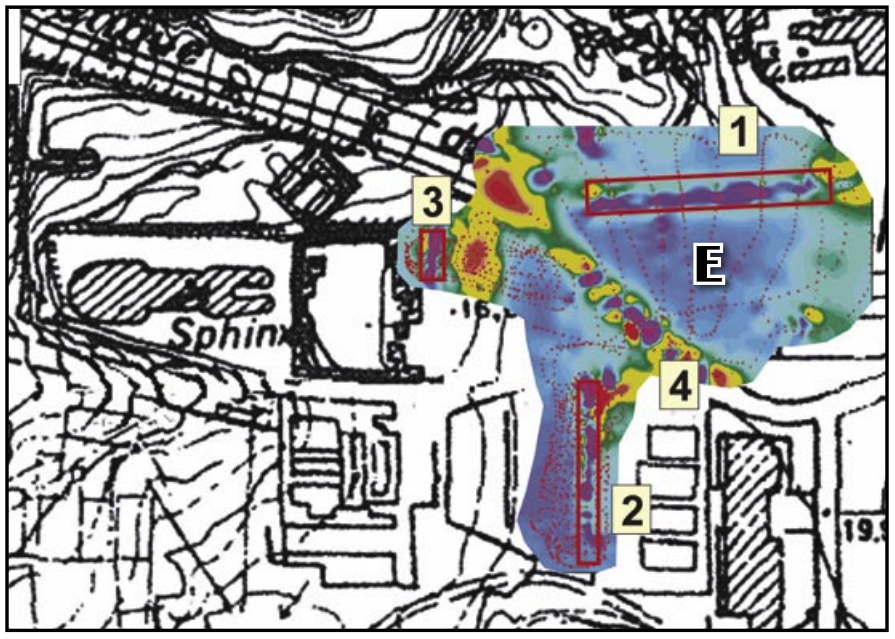
In an earlier edition of the AERAGram, from July 2004, a survey by Glen Dash titled Seeing Beneath the Surface provides scan imagery of the subsurface structures in the area east of the Sphinx Temple. When overlaying the ARE map, we find several anomalies along the path of the tunnel, which may be showing the antechambers Cayce described along the way. A small purple spot even appears at the entrance of the pyramid as it’s positioned.
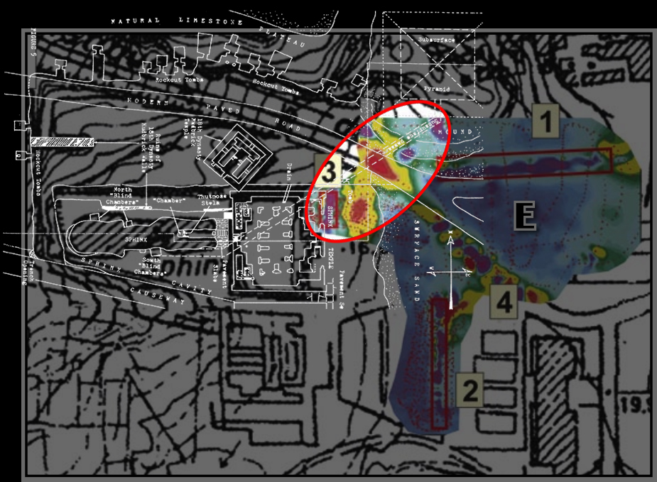
We can also see another tunnel bearing east from the anomalies, and one to the south, either of which could also connect to the pyramid.
Dr. Abbas Mohamed Abbas, with NRIAG (National Research Institute of Astronomy and Geophysics, Egypt) released additional remote sensing data from this area in 2006, in a report called GEOPHYSICAL MAPPING OF THE REMAINS OF CHEPHREN PYRAMIDAL COMPLEX, GIZA NECROPOLIS, EGYPT.
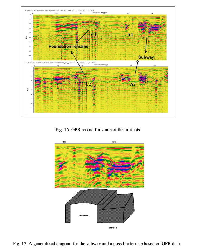
He also reports finding an underground ‘subway system’ east of the Valley Temple using Ground Penetrating Radar. He concludes his report saying:
“The second part in this work was to map the remains of the harbor platform and the
subway. To achieve this object, an integrated magnetic and GPR survey has been carried
out at the area separating the valley temple and the theater of Sound and Light. The
subway was detected and its location met the southern ramp at the entrance of the temple.
A proposal to excavate the site is under preparation.”
Though this report is now twenty years old, no excavation permits for the area have been issued to date.
Conclusions
The images from the Cayce Archives, despite being proposed as hypothetical layouts, help to visualize what the readings describe. Many additional scientific reports lend supporting evidence to indicate that the location suggested by both the ARE and Bill Brown independently, is the most logical location.
There are several key locations where non-invasive sensing or excavations could reveal an entrance into the tunnel system that ultimately connects to the record chambers.
- The vertical shaft beneath the South Large Box
- The additional entrances known on the Sphinx’s body, including 1. by the tail, 2. on the back fissure, 3. top of head, and 4. behind the Dream Stele
- The five or more entrances uncovered in the Cave Cleanup Project that were promptly sealed by authorities, and the dozen or more along the cliff extending west
- The tunnels detected by Glen Dash and Dr. Abbas east of the Sphinx and Valley Temples
- The entire demolished area of Nazlet El Samman, from the Stable to the Great Pyramid Causeway
- Most important of all, the Stable Property
If the Archaeological Rescue Foundation can raise sufficient funding, we can organize a mission to investigate these leads further and apply for permits from the Ministry of Tourism and Antiquities for remote sensing, core drilling and excavations. The evidence is extremely promising, and the record chambers, if discovered in full transparency, could alter the course of human history as we know it. Furthermore, excavation at the Stable location poses absolutely no risk whatsoever to any of the existing monuments, so while there is everything to gain, there is also nothing to lose.
Every element of this story leads to the inevitable conclusion that the Stable property, shown as the location of the Pyramid of Records by the leading researchers on the subject nearly half a century ago, should be professionally and securely excavated. That is precisely what Bill Brown and the Archaeological Rescue Foundation aim to accomplish.